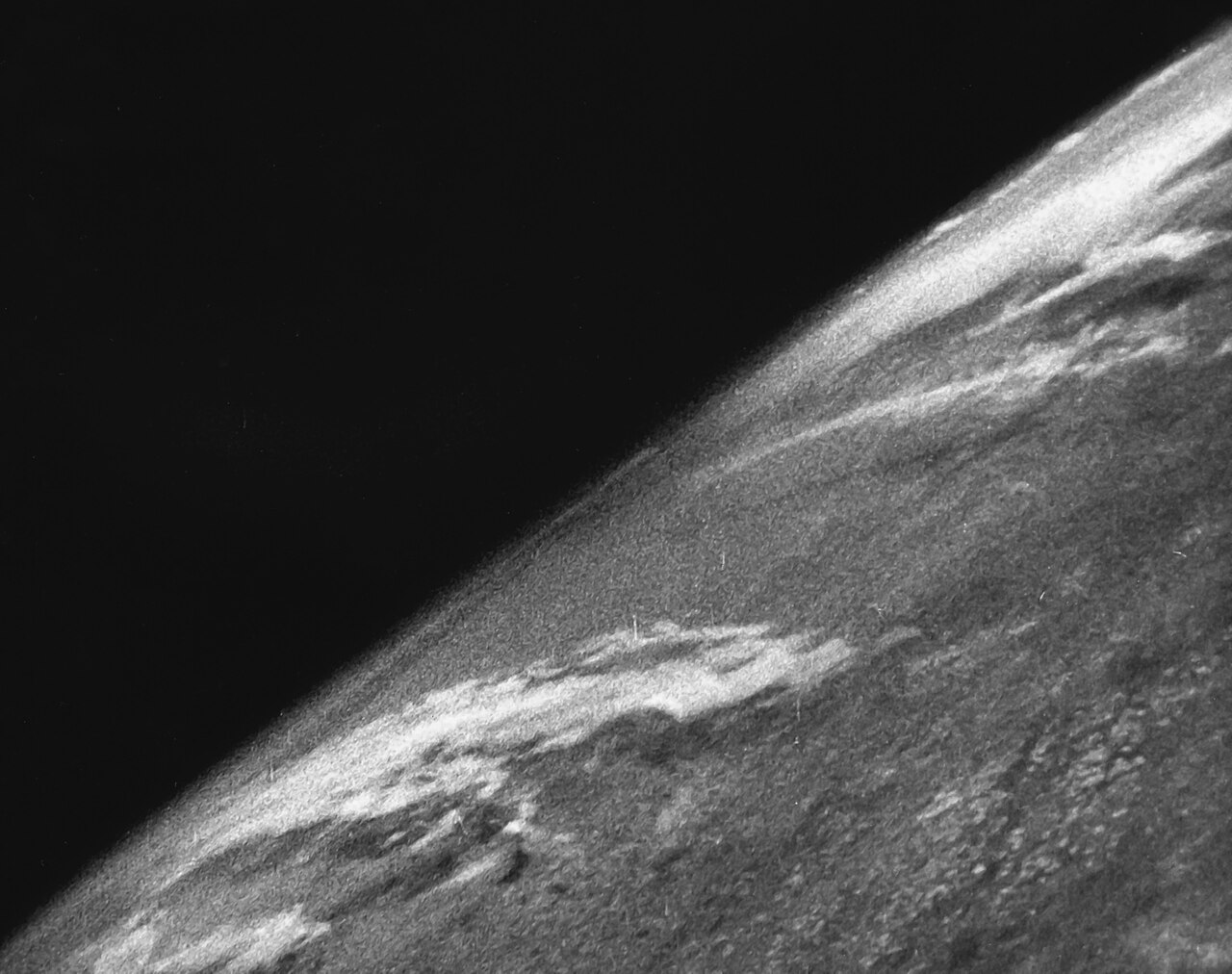
On October 24, 1946, a significant event that changed humanity's perspective on planet Earth took place in the desert region of New Mexico, United States. A modified military rocket, known as V-2 No. 13, was launched from the White Sands Missile Range site. This launch was not intended to test weapons of war, but rather a scientific mission that ultimately succeeded in taking the first photograph of planet Earth from outer space.
The historic photo was captured at an altitude of approximately 65 miles or 105 kilometers from sea level, thus crossing the Kármán line—the international boundary widely recognized as the beginning of outer space. The success of capturing images of the Earth from this extreme altitude provided the first visual evidence of our planet's curvature and the pitch-black background of space, something that had never been witnessed by human eyes before.
Post-World War II Science Race and the V-2 Program
To understand the significance of the V-2 No. 13 launch, its history must be viewed in the context of the immediate aftermath of World War II. The original V-2 rockets were ballistic missile weapons developed by the Nazi German military under the leadership of scientists such as Wernher von Braun. When the war ended in 1945, the United States military seized dozens of V-2 rocket components and brought them to the United States in a project known as Operation Paperclip.
Instead of leaving this technology idle or destroying it, American military scientists and engineers seized the opportunity to modify the rocket hardware into upper-atmosphere scientific research vehicles. The Applied Physics Laboratory at Johns Hopkins University, together with the US military, began equipping these rockets with various scientific instruments to measure temperature, pressure, cosmic radiation, and air composition in the upper layers of the atmosphere.
Launch Moment and the 35mm Film Camera Mission
On the day of the event, the V-2 No. 13 rocket was fitted with a specially modified 35mm motion picture camera. This camera was designed to take a picture every one and a half seconds throughout the rocket's flight into space. The main challenge faced by engineers at that time was not just carrying the camera to high altitudes, but ensuring that the photographic film could survive when the rocket crashed back to earth at speeds of hundreds of kilometers per hour.
To overcome this, the 35mm film was placed inside a thick and structurally sturdy steel cassette. When the rocket reached its peak altitude of 105 kilometers and subsequently fell back through the atmosphere before crashing into the earth, the rocket body was severely damaged and destroyed. However, the steel cassette protecting the film remained intact and unaffected.
Researchers who rushed to the crash site found the film inside the steel cassette to be in safe condition. When the film was processed in the laboratory, clear black-and-white images revealed the vast expanse of the Earth's landmass, thick cloud cover, and most impressively, the distinct curvature of planet Earth with the darkness of outer space in the background.
Legacy of Space Photography and Pioneer of the Satellite Era
The success of the V-2 No. 13 launch and the production of the first Earth photo had a profound impact on the scientific community and public perception. Before 1946, the highest photo ever captured was only taken from the Explorer II hot air balloon in 1935, which merely reached an altitude of about 22 kilometers. The launch of V-2 No. 13 drastically multiplied this altitude record and proved that photographic equipment could function in extreme space environments.
Experience and data from the V-2 program laid a solid foundation for the development of weather satellite technology, remote sensing photography, and crewed space exploration missions in the following decades such as the Mercury, Gemini, and Apollo programs. This first photo became a catalyst for human awareness of how fragile and isolated planet Earth is in the midst of the vastness of deep space.
To this day, the image produced by V-2 No. 13 on October 24, 1946, remains one of the most historic milestones in the annals of modern space exploration science and technology.
Source: Wikipedia — https://en.wikipedia.org/wiki/V-2_No.13 | License: CC BY-SA 4.0
1946: V-2 No. 13 Makes History by Capturing the First Photo of Earth from Space. On October 24, 1946, a modified V-2 No. 13 rocket was launched from the White Sands Missile Range in New Mexico, United States, reaching an altitude of 105 kilometers. This historic launch captured the first photograph of planet Earth from space using a 35mm film camera. This success not only proved the potential of post-World War II rocket science, but also opened a new chapter in space exploration and atmospheric science.. On October 24, 1946, a significant event that changed humanity's perspective on planet Earth took place in the desert region of New Mexico, United States. A modified military rocket, known as V-2 No. 13, was launched from the White Sands Missile Range site. This launch was not intended to test weapons of war, but rather a scientific mission that ultimately succeeded in taking the first photograph of planet Earth from outer space.
The historic photo was captured at an altitude of approximately 65 miles or 105 kilometers from sea level, thus crossing the Kármán line—the international boundary widely recognized as the beginning of outer space. The success of capturing images of the Earth from this extreme altitude provided the first visual evidence of our planet's curvature and the pitch-black background of space, something that had never been witnessed by human eyes before.
Post-World War II Science Race and the V-2 Program
To understand the significance of the V-2 No. 13 launch, its history must be viewed in the context of the immediate aftermath of World War II. The original V-2 rockets were ballistic missile weapons developed by the Nazi German military under the leadership of scientists such as Wernher von Braun. When the war ended in 1945, the United States military seized dozens of V-2 rocket components and brought them to the United States in a project known as Operation Paperclip.
Instead of leaving this technology idle or destroying it, American military scientists and engineers seized the opportunity to modify the rocket hardware into upper-atmosphere scientific research vehicles. The Applied Physics Laboratory at Johns Hopkins University, together with the US military, began equipping these rockets with various scientific instruments to measure temperature, pressure, cosmic radiation, and air composition in the upper layers of the atmosphere.
Launch Moment and the 35mm Film Camera Mission
On the day of the event, the V-2 No. 13 rocket was fitted with a specially modified 35mm motion picture camera. This camera was designed to take a picture every one and a half seconds throughout the rocket's flight into space. The main challenge faced by engineers at that time was not just carrying the camera to high altitudes, but ensuring that the photographic film could survive when the rocket crashed back to earth at speeds of hundreds of kilometers per hour.
To overcome this, the 35mm film was placed inside a thick and structurally sturdy steel cassette. When the rocket reached its peak altitude of 105 kilometers and subsequently fell back through the atmosphere before crashing into the earth, the rocket body was severely damaged and destroyed. However, the steel cassette protecting the film remained intact and unaffected.
Researchers who rushed to the crash site found the film inside the steel cassette to be in safe condition. When the film was processed in the laboratory, clear black-and-white images revealed the vast expanse of the Earth's landmass, thick cloud cover, and most impressively, the distinct curvature of planet Earth with the darkness of outer space in the background.
Legacy of Space Photography and Pioneer of the Satellite Era
The success of the V-2 No. 13 launch and the production of the first Earth photo had a profound impact on the scientific community and public perception. Before 1946, the highest photo ever captured was only taken from the Explorer II hot air balloon in 1935, which merely reached an altitude of about 22 kilometers. The launch of V-2 No. 13 drastically multiplied this altitude record and proved that photographic equipment could function in extreme space environments.
Experience and data from the V-2 program laid a solid foundation for the development of weather satellite technology, remote sensing photography, and crewed space exploration missions in the following decades such as the Mercury, Gemini, and Apollo programs. This first photo became a catalyst for human awareness of how fragile and isolated planet Earth is in the midst of the vastness of deep space.
To this day, the image produced by V-2 No. 13 on October 24, 1946, remains one of the most historic milestones in the annals of modern space exploration science and technology.
Source: Wikipedia — https://en.wikipedia.org/wiki/V-2 No. 13 License: CC BY-SA 4.0