🌍 Global coverage 24/7 • 🏯 East Asia: China, Japan, Korea • 🛕 South Asia: India • 🏰 Europe • 🗽 Americas • 🌍 Africa • 🕌 Middle East • 🇵🇸 Palestine Solidarity •
This article is a translation from the original language.
🕌 Stories & Lessons
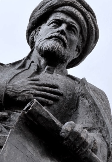
Piri Reis: The Ottoman Admiral Who Mapped the World Including the American Coastline
This article recounts the life and achievements of Piri Reis, a renowned Ottoman admiral and cartographer famous for his extraordinary 1513 world map, which remarkably depicted the American coastline with astonishing accuracy. Through his work, he connected the Islamic world with the Age of Exploration, leaving an enduring legacy in the history of cartography and navigation.
When the Old World Met the New: A Map That Changed History
Imagine a map drawn on deer skin in 1513, not only depicting the Atlantic Ocean and the coasts of Europe and Africa, but also recording the eastern coastline of America with surprising accuracy. This is the great work of Piri Reis, an Ottoman admiral and cartographer whose name is now synonymous with intellectual courage and technical excellence. This map is not just a geographical document; it is evidence that the Islamic civilization of the 16th century was not only a witness but also an active participant in the age of global exploration. With his pen and sharp observations, Piri Reis recorded a fragment of global history that connected East and West, old and new, in a beautiful sheet.
A Sailor, A Scientist: The Background of Piri Reis
Born around 1465 to 1470 in Gallipoli (Gelibolu), an important port city in the Ottoman Empire, Piri Reis began his life as Muhiddin Piri. The sea ran in his blood from an early age; his uncle, Kemal Reis, was a famous pirate who later became an Ottoman admiral. Alongside his uncle, young Piri sailed across the Mediterranean, joining pirate expeditions and naval battles. These experiences gave him practical knowledge about winds, currents, and ports, forming a solid foundation for his cartographic career. In 1495, he officially joined the Ottoman navy, and during the Ottoman-Venetian War (1499–1503), he demonstrated remarkable bravery and tactical skill, rising to command his own ship.
The 1513 World Map: Between Science and Mystery
Piri Reis's greatest achievement came in 1513 when he created the world map that is now iconic. This map, which only has a third of its western part remaining, shows the Atlantic Ocean, the coasts of Europe and Africa, and the eastern coastline of America, including Brazil and possibly Antarctica. What makes this map extraordinary is its relative accuracy at the time, especially in depicting South America. Piri Reis himself noted in his records that he used more than 20 map sources, including maps brought by Columbus, Portuguese maps, and old Arab maps. This indicates a systematic scientific approach, combining various cartographic traditions to create a more complete picture. The map was presented as a gift to Sultan Selim I in 1517, after Piri Reis participated in the conquest of Egypt. However, for centuries, the map was lost and rediscovered in 1929 at the Topkapi Palace Library in Istanbul, surprising the world with its excellence.
Kitab-ı Bahriye: An Ocean Atlas That Became a Reference
In addition to the world map, Piri Reis's greatest contribution was Kitab-ı Bahriye (Book of the Sea), a comprehensive nautical atlas. Published in two editions (1521 and 1526), the book contains detailed maps of harbors, bays, and routes in the Mediterranean, complete with sailing instructions, information about winds, currents, and sea dangers. More than just a practical guide, Kitab-ı Bahriye also includes illustrations of cities, historical information, and local stories, making it a rich maritime encyclopedia. The book was dedicated to Sultan Suleiman the Magnificent, who valued knowledge and art. For Ottoman and European sailors, Kitab-ı Bahriye became a primary reference for several generations, proving that Islamic cartography was not only equal but sometimes surpassed Western maps of that time.
Grand Admiral in the Indian Ocean: A Tragic End
In 1547, at the age of around 80, Piri Reis was appointed Grand Admiral (Kaptan-ı Derya) of the Ottoman fleet in the Indian Ocean, a great honor that showed the sultan's trust in him. He led an expedition against the Portuguese in the Persian Gulf and the Red Sea, but this mission did not go smoothly. Lack of supplies and support, combined with rivalry among officers, caused failure. When he returned to Suez without achieving his objectives, he was accused of failure and sentenced to death in 1553. Although his end was tragic, Piri Reis's legacy was not erased. His death was a great loss to the world of knowledge, but his works continued to live on.
Legacy of a Great Cartographer: A Bridge Between Eras
Piri Reis left a legacy that transcended his time. His world map is not only a valuable historical document but also a symbol of how the Islamic civilization actively participated in the Age of Exploration. He proved that Islamic cartography was advanced and open to external influences, combining Mediterranean sailing traditions with new knowledge from the New World. Kitab-ı Bahriye continues to be studied as a primary source for maritime and cartographic history. More importantly, the story of Piri Reis reminds us that at the peak of Islamic glory, scientists and sailors did not only preserve traditions but also innovated and contributed to global knowledge. The name of Piri Reis is now immortalized in modern maps, a crater on the Moon, and history textbooks, becoming an inspiration that knowledge knows no religious or national boundaries.
Conclusion: Drawing Lessons from the Oceans of Time
Piri Reis is living proof of how an individual can become a bridge between worlds. From the turbulent waters of the Mediterranean to the sultan's palace in Istanbul, he transformed his sailing experiences into lasting knowledge. His maps not only show coastlines but also bold, curious, and systematic lines of thought. In this digital era, we may forget how difficult it was to understand the world without satellite images. However, through Piri Reis's eyes, we see that with perseverance and love for knowledge, humans can record the beauty of this earth in its purest form. May his story continue to inspire new generations to explore, create, and leave meaningful legacies.
Piri Reis: The Ottoman Admiral Who Mapped the World Including the American Coastline. This article recounts the life and achievements of Piri Reis, a renowned Ottoman admiral and cartographer famous for his extraordinary 1513 world map, which remarkably depicted the American coastline with astonishing accuracy. Through his work, he connected the Islamic world with the Age of Exploration, leaving an enduring legacy in the history of cartography and navigation.. When the Old World Met the New: A Map That Changed History
Imagine a map drawn on deer skin in 1513, not only depicting the Atlantic Ocean and the coasts of Europe and Africa, but also recording the eastern coastline of America with surprising accuracy. This is the great work of Piri Reis, an Ottoman admiral and cartographer whose name is now synonymous with intellectual courage and technical excellence. This map is not just a geographical document; it is evidence that the Islamic civilization of the 16th century was not only a witness but also an active participant in the age of global exploration. With his pen and sharp observations, Piri Reis recorded a fragment of global history that connected East and West, old and new, in a beautiful sheet.
A Sailor, A Scientist: The Background of Piri Reis
Born around 1465 to 1470 in Gallipoli Gelibolu , an important port city in the Ottoman Empire, Piri Reis began his life as Muhiddin Piri. The sea ran in his blood from an early age; his uncle, Kemal Reis, was a famous pirate who later became an Ottoman admiral. Alongside his uncle, young Piri sailed across the Mediterranean, joining pirate expeditions and naval battles. These experiences gave him practical knowledge about winds, currents, and ports, forming a solid foundation for his cartographic career. In 1495, he officially joined the Ottoman navy, and during the Ottoman-Venetian War 1499–1503 , he demonstrated remarkable bravery and tactical skill, rising to command his own ship.
The 1513 World Map: Between Science and Mystery
Piri Reis's greatest achievement came in 1513 when he created the world map that is now iconic. This map, which only has a third of its western part remaining, shows the Atlantic Ocean, the coasts of Europe and Africa, and the eastern coastline of America, including Brazil and possibly Antarctica. What makes this map extraordinary is its relative accuracy at the time, especially in depicting South America. Piri Reis himself noted in his records that he used more than 20 map sources, including maps brought by Columbus, Portuguese maps, and old Arab maps. This indicates a systematic scientific approach, combining various cartographic traditions to create a more complete picture. The map was presented as a gift to Sultan Selim I in 1517, after Piri Reis participated in the conquest of Egypt. However, for centuries, the map was lost and rediscovered in 1929 at the Topkapi Palace Library in Istanbul, surprising the world with its excellence.
Kitab-ı Bahriye: An Ocean Atlas That Became a Reference
In addition to the world map, Piri Reis's greatest contribution was Kitab-ı Bahriye Book of the Sea , a comprehensive nautical atlas. Published in two editions 1521 and 1526 , the book contains detailed maps of harbors, bays, and routes in the Mediterranean, complete with sailing instructions, information about winds, currents, and sea dangers. More than just a practical guide, Kitab-ı Bahriye also includes illustrations of cities, historical information, and local stories, making it a rich maritime encyclopedia. The book was dedicated to Sultan Suleiman the Magnificent, who valued knowledge and art. For Ottoman and European sailors, Kitab-ı Bahriye became a primary reference for several generations, proving that Islamic cartography was not only equal but sometimes surpassed Western maps of that time.
Grand Admiral in the Indian Ocean: A Tragic End
In 1547, at the age of around 80, Piri Reis was appointed Grand Admiral Kaptan-ı Derya of the Ottoman fleet in the Indian Ocean, a great honor that showed the sultan's trust in him. He led an expedition against the Portuguese in the Persian Gulf and the Red Sea, but this mission did not go smoothly. Lack of supplies and support, combined with rivalry among officers, caused failure. When he returned to Suez without achieving his objectives, he was accused of failure and sentenced to death in 1553. Although his end was tragic, Piri Reis's legacy was not erased. His death was a great loss to the world of knowledge, but his works continued to live on.
Legacy of a Great Cartographer: A Bridge Between Eras
Piri Reis left a legacy that transcended his time. His world map is not only a valuable historical document but also a symbol of how the Islamic civilization actively participated in the Age of Exploration. He proved that Islamic cartography was advanced and open to external influences, combining Mediterranean sailing traditions with new knowledge from the New World. Kitab-ı Bahriye continues to be studied as a primary source for maritime and cartographic history. More importantly, the story of Piri Reis reminds us that at the peak of Islamic glory, scientists and sailors did not only preserve traditions but also innovated and contributed to global knowledge. The name of Piri Reis is now immortalized in modern maps, a crater on the Moon, and history textbooks, becoming an inspiration that knowledge knows no religious or national boundaries.
Conclusion: Drawing Lessons from the Oceans of Time
Piri Reis is living proof of how an individual can become a bridge between worlds. From the turbulent waters of the Mediterranean to the sultan's palace in Istanbul, he transformed his sailing experiences into lasting knowledge. His maps not only show coastlines but also bold, curious, and systematic lines of thought. In this digital era, we may forget how difficult it was to understand the world without satellite images. However, through Piri Reis's eyes, we see that with perseverance and love for knowledge, humans can record the beauty of this earth in its purest form. May his story continue to inspire new generations to explore, create, and leave meaningful legacies.
---
Reference: Piri Reis — Wikipedia https://en.wikipedia.org/wiki/Piri Reis