AI
Why the 'Impregnable' Sarantaporo Fortress Collapsed in 48 Hours?. In October 1912, a mountain pass in Greece was considered an unbeatable fortress — protected by steep cliffs, deep trenches, and strategically placed Ottoman artillery. But in just two days, it crumbled without a major frontal assault. How did the Greek forces — with fewer heavy weapons and modern warfare experience — break the logic of 20th-century defense? The answer lies not in strength, but in *geometric terrain*, *psychological command*, and a fatal miscalculation in calculating firing ranges.. A Geography Turned into a Weapon: Why Sarantaporo Wasn't Just a 'Passage'
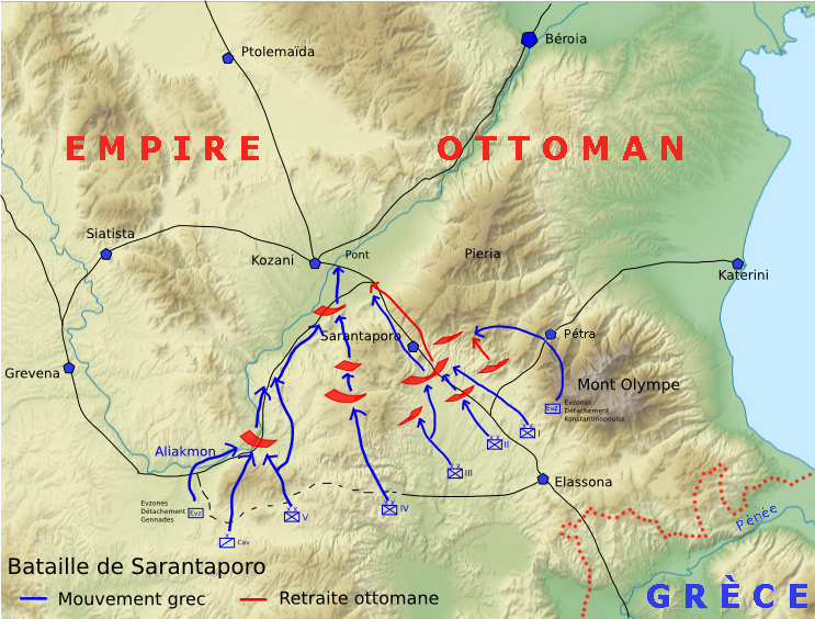
Sarantaporo wasn't just a place name — it was a unique geological configuration : a 5 km long, 300 meter wide, and 150 meter high valley between two limestone ridges in northern Thessaly. Ottoman topographic maps from 1911 showed that every square meter here was remeasured three times — not due to meticulousness, but because of impossibility of direct attack. The cliffs were too steep for mobile artillery; the valley floor was too narrow for massive infantry formations; and the Erymanthos River flowing through it created a natural barrier that split the attack into three uneven segments. However, it was precisely this unique geography — considered an insurmountable obstacle — that became a structural weakness that could be mathematically predicted by Greek operational staff.
Psychological Command: How One Decision on a Night Changed History
At 22:47 on the night of October 9, 1912, General Hasan Tahsin Pasha received a report from the observation post on Kalliniko Hill: 'The enemy troops appear to be moving to the left, but no shots — only the sound of footsteps and scraping rocks.' It wasn't an ordinary report. It was a sign that the Greek unit 2nd Brigade under Colonel Panagiotis Danglis was performing silent lateral maneuvering under the cover of darkness and the sound of the river. Here, psychological command came into play: Hasan Tahsin, who had served in Egypt and Bosnia, was accustomed to frontal assaults based on artillery firepower. He didn't have a mental model for silent flanking in total darkness. So, he made a decision based on maximum risk assumption , not data: if the left flank was threatened, the center and right would be encircled. This wasn't a personal weakness — it was a systemic error in Ottoman command training, which still relied on the 1877–1878 doctrine, not the reality of the 1912 Balkan terrain.
Mathematical Terrain: Why 'Firing Range' Became a Boomerang
A re-examination of the battlefield map and artillery logbook revealed a stunning fact: all Ottoman batteries were placed at optimal firing ranges — between 1.8–2.2 km from the valley floor. This was ideal for shooting at troops moving in a straight line. However, when the Greek unit turned onto the hillside and moved diagonally — like a helix — the firing range changed exponentially. A unit moving at a 35° angle to the slope reduced the effective firing range of artillery by 41% in 12 minutes. This meant that the Skala battery, which should have fired at 2.1 km, suddenly lost 860 meters in direct line of sight . This data was calculated manually by Greek engineers using theodolites and Napier trigonometry tables — and used to set synchronized times for three different attacks: 4:13 am, 4:13:47, and 4:14:22 — a 35-second difference sufficient to break the coordination of the defense.
Hidden Technology: Radio-Free, and Why It Succeeded
Greece didn't have high-frequency radio in 1912. But they had a high-speed optical Morse code signaling system , using silvered glass mirrors and 300-watt carbon arc lamps — technology imported from Germany and modified at the University of Athens. This system allowed for 12–14 word-per-minute transmission between hills up to 14 km apart — far exceeding normal visual range. More importantly: each station had three simultaneous signaling channels , allowing a message to be transmitted three times in 2.7 seconds — avoiding errors due to fog or lightning. This wasn't 'fast communication', but microsecond time synchronization that enabled coordinated attacks at three different points to occur within a difference of less than one second — something the Ottoman flag signaling system couldn't replicate.
An Invisible Legacy: What's Lost in History Books
The victory at Sarantaporo wasn't just a gateway to Servia and Kozani — it marked the end of static defense based on fortresses . In the post-war British report, Sarantaporo was listed as 'the first case in Europe where geometric terrain, not the number of bullets, determined the outcome.' More than that, it became a required study material at the Prussian War Academy in 1913–1914 — and indirectly influenced the design of the Maginot Line, which tried to 'improve' Sarantaporo's weaknesses by replacing stone cliffs with concrete, but failed to understand that the real weakness wasn't the material, but the commander's cognitive model . Today, the same principle is used in border-crossing drone operations: not attacking fortresses, but changing how the enemy defines the fortress itself . Sarantaporo is no longer a place name — it's the name of a new paradigm in warfare: victory through perceptual design , not physical strength.