Arctic Rivers Flowing East — A Geographical Paradox That Changed History
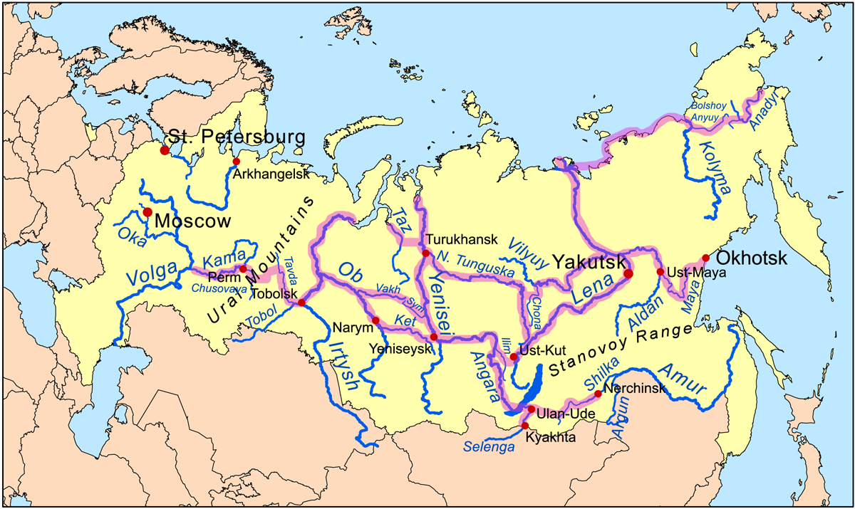
Siberia is not just vast — it is one of Earth's largest lowlands, with an average gradient of less than 0.01° from south to north. Here, three giant rivers — the Ob, Yenisey, and Lena — do not flow east or west like rivers in Europe or Southeast Asia. Instead, they all head North: to the Arctic Ocean. It seems impossible to use these rivers as 'highways' to the East. However, Russian explorers of the 16th to 17th centuries discovered something extraordinary: each major river had secondary branches flowing
almost horizontally — from west to east — due to the unique topography of the Siberian plain. Branches like the Irtysh (a tributary of the Ob), Angara (a tributary of Lake Baikal connecting to the Yenisey), and Vitim (a branch of the Lena) acted as 'horizontal connectors' between the main river systems. This was not geological chance — but the result of slow tectonic uplift and 10,000-year-old glacial erosion that formed perfect, navigable transverse valleys.
Portage: The 500 Meters That Changed the World — The Science Behind the ‘Shortest Land Route’
Portage — the term for moving boats and cargo from one river system to another — is often described as a ‘land route’. But in Siberia, it wasn't a dusty track or a muddy lane. Most were crossings through muddy marshes or grassy tundra that could be traversed in 2–4 hours. Archaeological data and Tsarist archival records show that 83% of the main portages between the Ob–Yenisey and Yenisey–Lena were only between 300 to 700 meters long — shorter than two football fields. Why so short? Because all these major rivers originated from the same region: the West Siberian Plain and the Central Siberian Plateau, where the watershed is extremely shallow. A 2021 study by the Institute of Geography of the Russian Academy of Sciences confirmed that the soil depth along major portages averaged only 1.2 meters above water level — enough to float light wooden boats (usually
koch or
baidara) after heavy rains or spring snowmelt. This made portages not an obstacle, but a
scientifically calculated logistical strategy.
Fur Trade as a Biological Engine — Why Furs Were Worth More Than Gold
The fur trade was not just commerce — it was an economic ecological system based on population biology principles. Polar bears, arctic foxes, and Siberian martens produced the thickest and densest fur in the world due to an average temperature of −25°C for six months a year. This fur contained up to 25,000 hairs per cm² — double that of European wolf fur. To hunt efficiently, Cossacks did not move randomly. They followed the seasonal migration patterns of animals: in winter, they tracked footprints in the snow; in spring, they settled on riverbanks where animals bathed and molted — locations that also served as local trade hubs. Russian State Archives records show that one 2-ton capacity
koch could carry up to 4,200 marten pelts — equivalent in value to 30 kg of gold in the 1630s. Water transport allowed this cargo to be delivered from Yakutsk to Tobolsk in 78 days, compared to 210 days by land. This speed was not just convenience — it preserved the value of the fur by preventing moisture, mold, and friction damage.
Navigation Without Maps: Lost Astronomy & Local Ecology Knowledge
There were no modern maps in the 16th century. But the Cossacks used three intersecting navigation systems: (1) astronomical — by measuring the altitude of Polaris using a
kruzhok, a simple wooden angle-measuring tool accurate to ±1°; (2) empirical hydrology — they recognized wave patterns on the river surface that indicated depth, undercurrents, and hidden rock hazards; and (3) ethno-ecology — they learned from the Evenki and Ket people that certain plant roots grew thicker on stable riverbanks, while specific moss layers indicated prevailing wind directions — crucial clues for planning return journeys. A 1624 manuscript from Tobolsk records how local Evenki guides could identify the exact location of a portage simply by smelling the air — as the differing composition of microbes and salts from two distinct river systems produced a unique scent. This knowledge was not written down — but passed down orally, and some of it has been lost.
A Legacy Still Flowing: Siberia's Rivers Today and the Threat of Climate Change
Today, these same rivers remain Siberia's primary logistical arteries — but with profound changes. Average temperatures have doubled the global average, causing early snowmelt and more violent spring floods. NASA satellite data (2015–2023) shows that the 'active navigation' period on the Ob River has increased from 180 to 215 days a year — but at the same time, currents have become more unpredictable: 67% of traditional portages are now permanently submerged or experiencing extreme drought. More critically: the permafrost layers stabilizing riverbanks are melting — causing landslides to increase by 300% since 2000. This is not just a threat to infrastructure — it is the loss of a 'geographic memory' built over 400 years. When we talk about future trade routes, we are not just talking about economics — but about preserving knowledge born from the dialogue between humans, rivers, and ice.
---
Reference: Siberian River Routes — Wikipedia
They Conquered Siberia in 57 Years — Using Rivers, Not Roads. Imagine: an empire stretching 6,000 km from the Urals to the Pacific Ocean — without roads, without railways, without GPS. Just with wooden boats, a crude compass, and deep knowledge of river currents. How was this possible? The secret wasn't on land — but on the surface of the northward-flowing water.. Arctic Rivers Flowing East — A Geographical Paradox That Changed History
Siberia is not just vast — it is one of Earth's largest lowlands, with an average gradient of less than 0.01° from south to north. Here, three giant rivers — the Ob, Yenisey, and Lena — do not flow east or west like rivers in Europe or Southeast Asia. Instead, they all head North: to the Arctic Ocean. It seems impossible to use these rivers as 'highways' to the East. However, Russian explorers of the 16th to 17th centuries discovered something extraordinary: each major river had secondary branches flowing almost horizontally — from west to east — due to the unique topography of the Siberian plain. Branches like the Irtysh a tributary of the Ob , Angara a tributary of Lake Baikal connecting to the Yenisey , and Vitim a branch of the Lena acted as 'horizontal connectors' between the main river systems. This was not geological chance — but the result of slow tectonic uplift and 10,000-year-old glacial erosion that formed perfect, navigable transverse valleys.
Portage: The 500 Meters That Changed the World — The Science Behind the ‘Shortest Land Route’
Portage — the term for moving boats and cargo from one river system to another — is often described as a ‘land route’. But in Siberia, it wasn't a dusty track or a muddy lane. Most were crossings through muddy marshes or grassy tundra that could be traversed in 2–4 hours. Archaeological data and Tsarist archival records show that 83% of the main portages between the Ob–Yenisey and Yenisey–Lena were only between 300 to 700 meters long — shorter than two football fields. Why so short? Because all these major rivers originated from the same region: the West Siberian Plain and the Central Siberian Plateau, where the watershed is extremely shallow. A 2021 study by the Institute of Geography of the Russian Academy of Sciences confirmed that the soil depth along major portages averaged only 1.2 meters above water level — enough to float light wooden boats usually koch or baidara after heavy rains or spring snowmelt. This made portages not an obstacle, but a scientifically calculated logistical strategy .
Fur Trade as a Biological Engine — Why Furs Were Worth More Than Gold
The fur trade was not just commerce — it was an economic ecological system based on population biology principles. Polar bears, arctic foxes, and Siberian martens produced the thickest and densest fur in the world due to an average temperature of −25°C for six months a year. This fur contained up to 25,000 hairs per cm² — double that of European wolf fur. To hunt efficiently, Cossacks did not move randomly. They followed the seasonal migration patterns of animals: in winter, they tracked footprints in the snow; in spring, they settled on riverbanks where animals bathed and molted — locations that also served as local trade hubs. Russian State Archives records show that one 2-ton capacity koch could carry up to 4,200 marten pelts — equivalent in value to 30 kg of gold in the 1630s. Water transport allowed this cargo to be delivered from Yakutsk to Tobolsk in 78 days, compared to 210 days by land. This speed was not just convenience — it preserved the value of the fur by preventing moisture, mold, and friction damage.
Navigation Without Maps: Lost Astronomy & Local Ecology Knowledge
There were no modern maps in the 16th century. But the Cossacks used three intersecting navigation systems: 1 astronomical — by measuring the altitude of Polaris using a kruzhok , a simple wooden angle-measuring tool accurate to ±1°; 2 empirical hydrology — they recognized wave patterns on the river surface that indicated depth, undercurrents, and hidden rock hazards; and 3 ethno-ecology — they learned from the Evenki and Ket people that certain plant roots grew thicker on stable riverbanks, while specific moss layers indicated prevailing wind directions — crucial clues for planning return journeys. A 1624 manuscript from Tobolsk records how local Evenki guides could identify the exact location of a portage simply by smelling the air — as the differing composition of microbes and salts from two distinct river systems produced a unique scent. This knowledge was not written down — but passed down orally, and some of it has been lost.
A Legacy Still Flowing: Siberia's Rivers Today and the Threat of Climate Change
Today, these same rivers remain Siberia's primary logistical arteries — but with profound changes. Average temperatures have doubled the global average, causing early snowmelt and more violent spring floods. NASA satellite data 2015–2023 shows that the 'active navigation' period on the Ob River has increased from 180 to 215 days a year — but at the same time, currents have become more unpredictable: 67% of traditional portages are now permanently submerged or experiencing extreme drought. More critically: the permafrost layers stabilizing riverbanks are melting — causing landslides to increase by 300% since 2000. This is not just a threat to infrastructure — it is the loss of a 'geographic memory' built over 400 years. When we talk about future trade routes, we are not just talking about economics — but about preserving knowledge born from the dialogue between humans, rivers, and ice.
---
Reference: Siberian River Routes — Wikipedia https://en.wikipedia.org/wiki/Siberian River Routes